Useful Tree Species for Eastern Africa
a species selection tool based on the VECEA Map
Desert (D)
Description
White (1983) does not think that there is an objective criterion to separate arid regions from wet regions, although he also mentions that semi-desert areas usually begin to appear where the mean annual rainfall drops below 250 mm, the southern boundary of the Sahara desert corresponds to the 150 mm isohyet and the northern boundary of the Sahara desert corresponds to the 100 mm isohyet. However, he defines semi-deserts ( S ) as areas where the differences in soil characteristics (such as soil colour) are more conspicuous than the vegetation itself, but where the plants are still sufficiently evenly distributed so that the vegetation can be further classified in physiognomic categories such as “semi-desert grassland” and “semi-desert shrubland” (White 1983 pp. 52 - 53). We therefore think that deserts can be defined as “areas where the differences in soil characteristics (such as soil colour) are more conspicuous than the vegetation itself and where the individual plants are never abundant enough in large enough areas to justify the classification of the vegetation as another physiognomic vegetation type such as grassland or shrubland” (see also White 1983 p. 53).
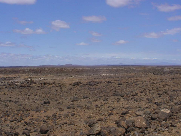
Some areas contain desert for edaphic reasons rather than having rainfall below certain limits. Various edaphic desert areas occur in northern Kenya on extensive stone pavement areas, in mosaic with semi-desert shrubland and dwarf bushland ( S; White 1983 p. 53). An investigation of environmental limits showed that the driest desert areas occur in Ethiopia (see VECEA Volume 5 ). Some areas covered with rock or snow on mountain peaks were classified by VECEA as the subtype of “Afromontane deserts (Ad)”.
F. Gachathi 2009; Figure 5.2 in VECEA Volume 5
Plant species
The main species recorded to occur within this vegetation type are listed below. Clicking the name of any of these species will open the page for that species on the Agroforestry Species Switchboard. Between brackets the English vernacular name of the species and the documented country distribution of the species (B=Burundi, E=Ethiopia, K=Kenya, M=Malawi, R=Rwanda, T=Tanzania, U=Uganda, Z=Zambia) is provided.
Based on information on species presence in national manifestations of vegetation types, each species was classified as a regionally dominant, characteristic, present or marginal species for a vegetation type (Read more ...)
- Dominant - if the regional documentation classified the species as dominant.
- Characteristic - if the species was documented to be characteristic for at least half of all the national manifestations of the vegetation type and if the species was characteristic in at least two national manifestations of the vegetation type. Species were always classified as characteristic if the species was a regional indicator or regional characteristic species for the vegetation type.
- Present - if the species was documented to be characteristic in at least one of the national manifestations of the vegetation type or if the species was documented to be present in a least half of all the national manifestations of the vegetation type. Species that were already listed as characteristic were excluded.
- Marginal distribution - if some of the national documentation listed the species, but where the species was not included as characteristic or present.
For more detailed information about the species occurrences see this excel workbook. It provides country specific information on species composition for this vegetation type. It also allows you to select a subset of useful tree species to provide desired products and services. For each species links to a number of websites / databases with information about this species are provided as well.
Conservation status
The table shows the area (km2) of the vegetation type and the percentage of this area explicitly designated for biodiversity, species or landscape protection (A) and areas designated for both protection and sustainable use objectives (B). Only the nationally designated protected areas were included.
| PNV | Area (km2) | A (%) | B (%) |
| D | 42,285 | 3.90 | 0.00 |
A) Include the IUCN categories I - IV; B) Include the IUCN categories V - VI and the protected areas without IUCN classification. Read more
There are seven different International Union for Conservation of Nature (IUCN)
management categories, based on their principle management objectives. Six of these can be found in the VECEA region. Based on
van Breugel et al. (2015), we reclassified these six categories into two groups. The first (A) is composed of the IUCN categories Ib, II, III and IV, all of which are explicitly designated for biodiversity, species or landscape protection. The second (B) is composed of IUCN category V, designated to protect a landscape created through interaction of people and nature, and VI, which is designated for both protection and sustainable use objectives. In group B we also included the protected areas not classified into one of the IUCN categories. These include different types of national or community forest reserves and areas that have a focus on wildlife or game management. It should be noted that the aggregation of the protected areas in these two groups (A and B) does not imply any assumptions from our side on the effectiveness of the management in these different categories.
Links
Species selection tool
Other vegetation types
//vegetationmap4africa.org
Documentation
Citation and terms of use
Click here for the full terms of use, disclaimer and errors and omissions statement that accompanies our data. When using our data, you agree with these terms.
Citation
Kindt R, van Breugel P, Orwa C, Lillesø JPB, Jamnadass R and Graudal L (2015) Useful tree species for Eastern Africa: a species selection tool based on the VECEA map. Version 2.0. World Agroforestry Centre (ICRAF) and Forest & Landscape Denmark. //vegetationmap4africa.org
van Breugel P, Kindt R, Lillesø JPB, Bingham M, Demissew S, Dudley C, Friis I, Gachathi F, Kalema J, Mbago F, Moshi HN, Mulumba, J, Namaganda M, Ndangalasi HJ, Ruffo CK, Védaste M, Jamnadass R and Graudal L (2015) Potential Natural Vegetation Map of Eastern Africa (Burundi, Ethiopia, Kenya, Malawi, Rwanda, Tanzania, Uganda and Zambia). Version 2.0. Forest and Landscape (Denmark) and World Agroforestry Centre (ICRAF). URL: //vegetationmap4africa.org
van Breugel P, Kindt R, Lillesø J-PB, van Breugel M (2015) Environmental Gap Analysis to Prioritize Conservation Efforts in Eastern Africa. PLoS ONE 10(4): e0121444. doi:10.1371/journal.pone.0121444
Terms of use
1) The data and tools on //vegetationmap4africa.org can be freely downloaded and used for educational, conservation and research purposes.
2) The recipient of the data will provide a full and appropriate acknowledgement and citation (see above) in any materials or publications derived in part or in whole from the data. For any publications making substantial use of the data, the VECEA team welcome the opportunity for coauthorship, collaboration and to comment prior to publication. Expressions of interest can be send using the contact form.
3) Reproduction of the dataset or products derived from it, either whole or in part, for commercial purposes is prohibited without prior written permission of the VECEA team. For the purposes of these Terms of Use, "commercial purposes" means a) any use by, on behalf of, or to inform or assist the activities of, a commercial entity (an entity that operates "for profit") or b) use by any non-profit entity for the purposes of revenue generation. If you require permission please email info@ecodiv.org
4) The recipient will not pass the original datasets on to third parties and will direct all requests for use of the data back to //vegetationmap4africa.org.
5) The recipient will not publish the data in their original format, either whole or in part, on a website, FTP site, CD, memory stick or any other media. The recipient should provide a link to the original data source location on the //vegetationmap4africa.org website where appropriate.
6) The recipient may only pass on datasets derived from these maps if the derived data are supplied with the same terms of use.
7) Use of these data does not constitute endorsement by the VECEA team or its partners of any derived products, reports or analyses.
8) The data are provided with additional supporting metadata, describing how they were compiled, ownership, type and quality of data, and limitations. The recipient must read all supporting information prior to any analysis and agree to abide by any stipulations contained therein. We cannot accept responsibility for the consequences of errors or omissions in the data, for misuse of the data by any organisation or individual, or for any damage done to computing systems into which the data are entered (see Disclaimer below).
9) The VECEA team will be informed about any products published using these data
Disclaimer
The VECEA team and its partners make no warranties or representations, express or implied, regarding the use of the material appearing in this dataset with regard to their correctness, reliability, accuracy, or otherwise. The material and geographic designations in this dataset do not imply the expressions of any opinion whatsoever on the part of the VECEA team, the Copenhagen University or the World Agroforestry Center concerning the legal status of any country, territory or area, nor concerning the delimitation of its frontiers or boundaries. The VECEA team, the Copenhagen University nor the World Agroforestry Center shall be responsible or liable to any person, firm or corporation for any loss, damage, injury, claim or liability of any kind or character based on or resulting from any information contained in the dataset.
Errors and omissions
The VECEA team endeavour to maintain accurate and up-to-date data at all times. However, if errors or omissions are identified, the user should notify the VECEA team so that they can be corrected in future releases of the data. Users can contact the VECEA team using the contact form.